
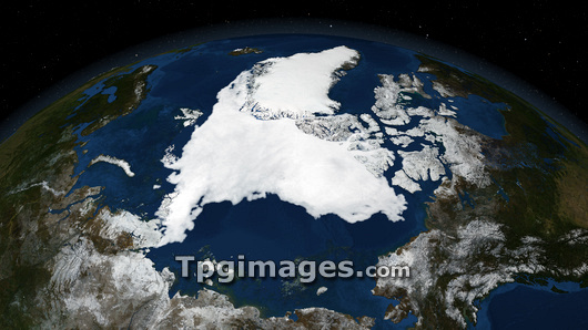
Arctic ice minimum extent, 2007. Satellite image showing the Arctic polar ice cap (centre), with Greenland (upper centre) and the Northwest Passage (centre right), a strip of sea connecting the Atlantic Ocean (top) to the Pacific Ocean (bottom right). The receding sea ice widened the Northwest Passage, making it fully open in August 2007. Declining sea ice is due to global warming, and the Arctic temperatures were at a record high in 2007, having risen by 1.7-2.2 degrees Celsius in the past century. The East Siberian Sea (lower centre) and the Barents Sea (upper left) are also seen. Photographed on 14th September 2007 by the Advanced Microwave Scanning Radiometer (AMSR-E) instrument aboard NASA's Aqua satellite.
| px | px | dpi | = | cm | x | cm | = | MB |
Details
Creative#:
TOP03206961
Source:
達志影像
Authorization Type:
RM
Release Information:
須由TPG 完整授權
Model Release:
N/A
Property Release:
N/A
Right to Privacy:
No
Same folder images:
 Loading