
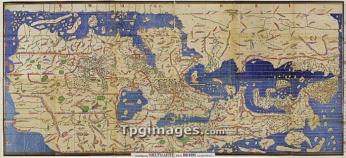
Al-Idrisi's world map. This world map, known as the 'Tabula Rogeriana', dates from 1154, and is orientated with North at bottom. It was drawn by Muhammad Al-Idrisi (1100-1165), an Islamic and Andalusian scholar working for King Roger II of Sicily. It is considered to have been the most accurate world map for the next three centuries. Regions shown include Europe (lower right), the Mediterranean Sea (centre right), North Africa (upper right), the Arabian Peninsula (upper centre), the Black Sea and Caspian Sea (lower centre), and parts of Asia (left). This is a restoration and transliteration carried out in 1927 by the German scholar Konrad Miller (1844-1933).
| px | px | dpi | = | cm | x | cm | = | MB |
Details
Creative#:
TOP06661620
Source:
達志影像
Authorization Type:
RM
Release Information:
須由TPG 完整授權
Model Release:
NO
Property Release:
NO
Right to Privacy:
No
Same folder images:
 Loading