
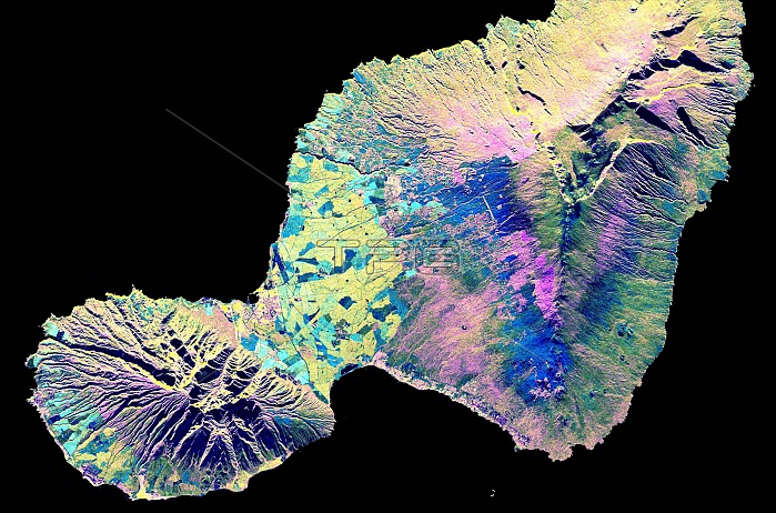
Spaceborne radar image shows the "Valley Island" of Maui, Hawaii. The light blue and yellow areas in the lowlands near the center are sugar cane fields. The three major population centers, Lahaina on the left at the western tip of island, Wailuku left of center, and Kihei in the lower center appear as small yellow, white or purple mottled areas. West Maui volcano, in the lower left, is 5900 feet and is considered extinct. The entire eastern half of the island consists of East Maui volcano, which rises to an elevation of 10,500 feet and features a spectacular crater called Haleakala at its summit. Rain forests appear in yellow, while grassland is shown in dark green, pink and blue. Radar images such as this one are being used by scientists to understand volcanic processes and to assess potential threats that future activity may pose to local populations. Image was acquired by Spaceborne Imaging Radar-C/X-Band Synthetic Aperture Radar (SIR-C/X-SAR) onboard the space shuttle Endeavour, April 16, 1994.
| px | px | dpi | = | cm | x | cm | = | MB |
Details
Creative#:
TOP22083147
Source:
達志影像
Authorization Type:
RM
Release Information:
須由TPG 完整授權
Model Release:
N/A
Property Release:
No
Right to Privacy:
No
Same folder images:
 Loading