
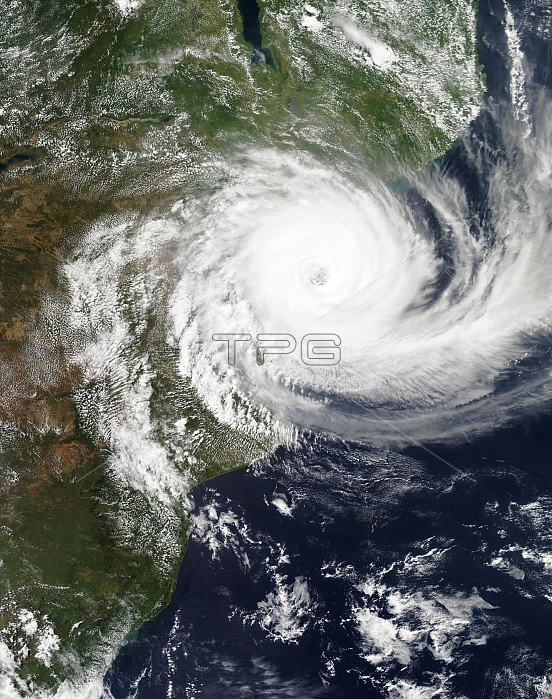
Cyclone Idai landfall in Mozambique. Satellite image of Cyclone Idai, shortly after reaching its peak intensity, approaching the Sofala province of Mozambique. The cyclone brought winds of over 195 kilometres per hour, devastating the port city of Beira, causing hundreds of death and extensive destruction, with hundreds of thousands affected by flooding. This image was obtained on 14 March 2019, by the MODIS (Moderate Resolution Imaging Spectroradiometer) sensor on NASA's Aqua satellite.
| px | px | dpi | = | cm | x | cm | = | MB |
Details
Creative#:
TOP24613829
Source:
達志影像
Authorization Type:
RM
Release Information:
須由TPG 完整授權
Model Release:
N/A
Property Release:
N/A
Right to Privacy:
No
Same folder images:
AFRICANCLOUDSCOASTCOASTALCYCLONICEARTHOBSERVINGSYSTEMDATAANDINFORMATIONSYSTEMEODISEODISWORLDVIEWEXTREMEWEATHERFROMSPACEIMPACTLANDFALLMETEOROLOGICALMODERATERESOLUTIONIMAGINGSPECTRORADIOMETERMOZAMBICANNATURALDISASTERNO-ONENOBODYPEAKINTENSITYCYCLONEHURRICANEAFRICAINDIANOCEANMOZAMBIQUEBERIASOFALAMETEOROLOGYEARTHOBSERVATIONSATELLITEIMAGESATELLITEAQUAMODIS21STCENTURY201914MARCH2019
142019201921STAFRICANANDAQUABERIACENTURYCLOUDSCOASTCOASTALCYCLONECYCLONICDATADISASTEREARTHEARTHEODISEODISEXTREMEFROMHURRICANEAFRICAIMAGEIMAGINGIMPACTINDIANINFORMATIONINTENSITYLANDFALLMARCHMETEOROLOGICALMETEOROLOGYMODERATEMODISMOZAMBICANMOZAMBIQUENATURALNO-ONENOBODYOBSERVATIONOBSERVINGOCEANPEAKRESOLUTIONSATELLITESATELLITESOFALASPACESPECTRORADIOMETERSYSTEMSYSTEMWEATHERWORLDVIEW
 Loading