
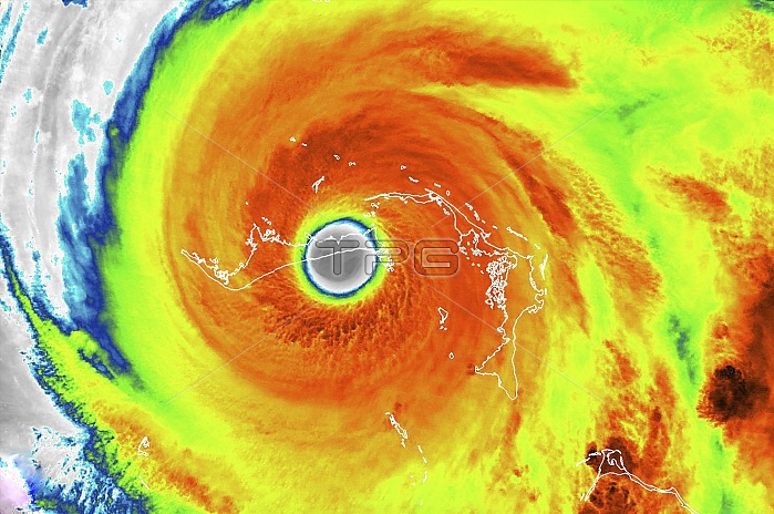
Hurricane Dorian over the Bahamas, infrared satellite image. Hurricane Dorian reached category 5 strength on 1 September 2019, making landfall in the Bahamas where it caused extensive damage and flooding due to high winds, prolonged rainfall and storm surges, especially on islands and associated islands of Great Abaco and Grand Bahama (labelled). This image was obtained on 2 September 2019, by the Visible Infrared Imaging Radiometer Suite (VIIRS) sensor on the Suomi NPP (National Polar-orbiting Partnership) satellite.
| px | px | dpi | = | cm | x | cm | = | MB |
Details
Creative#:
TOP25065516
Source:
達志影像
Authorization Type:
RM
Release Information:
須由TPG 完整授權
Model Release:
N/A
Property Release:
N/A
Right to Privacy:
No
Same folder images:
CYCLONICSTORMEYEOFTHESTORMFALSE-COLOUREDGEOGRAPHICALHURRICANEEYEIRMETEOROLOGICALNATIONALPOLAR-ORBITINGPARTNERSHIPNO-ONENOBODYVISIBLEINFRAREDIMAGINGRADIOMETERSUITEWEATHERHURRICANETROPICALCYCLONESTORMATLANTICOCEANBAHAMASCARIBBEANEARTHOBSERVATIONGEOGRAPHYMETEOROLOGYSATELLITEIMAGEINFRAREDCOLOUREDFROMSPACESUOMINPPVIIRS21STCENTURY20192SEPTEMBER2019
22019201921STBAHAMASCARIBBEANCENTURYCOLOUREDCYCLONECYCLONICEARTHEYEEYEFALSE-COLOUREDFROMGEOGRAPHICALGEOGRAPHYHURRICANEHURRICANEIMAGEIMAGINGINFRAREDINFRAREDIRMETEOROLOGICALMETEOROLOGYNATIONALNO-ONENOBODYNPPOBSERVATIONOCEANOFPARTNERSHIPPOLAR-ORBITINGRADIOMETERSATELLITESEPTEMBERSPACESTORMSTORMSTORMATLANTICSUITESUOMITHETROPICALVIIRSVISIBLEWEATHER
 Loading