
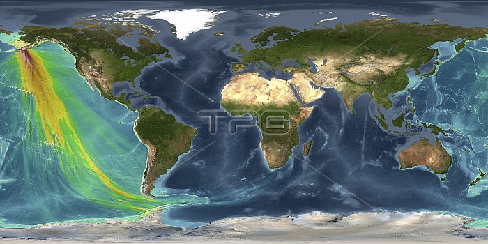
Tsunami from 1946 Aleutian Islands earthquake. Computer model showing the energy map and wave amplitudes caused by the tsunami triggered by the 1946 Aleutian Islands earthquake, centred off the Aleutian Island of Alaska. The height of the waves are colour-coded: blue-to-green represents less than 30 centimetres, yellow-to-orange indicates 30 to 100 centimetres, light red-to-bright red indicates 1 to 3 metres, and dark red indicates greater than 3 metres. This powerful earthquake took place on 1 April 1946, killing five lighthouse keepers on Unimak Island. Some 170 people were killed when the resulting tsunami reached Hawaii. This image was produced using the Real-Time Forecasting of Tsunamis (RIFT) forecast model from the Pacific Tsunami Warning Center (PTWC).
| px | px | dpi | = | cm | x | cm | = | MB |
Details
Creative#:
TOP25186171
Source:
達志影像
Authorization Type:
RM
Release Information:
須由TPG 完整授權
Model Release:
N/A
Property Release:
N/A
Right to Privacy:
No
Same folder images:
 Loading