
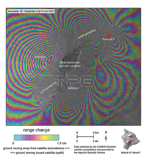
Radar interferogram of Mauna Loa, Hawaii, USA, between the 16th November 2022 until the 2nd December 2022. Radar interferometry is a technique where two or more satellite radar images acquired over the same area are combined to map surface topography and detect surface changes. On the 27th November 2022, the volcano began erupting for the first time since 1984. This image shows areas of deflation where magma has flowed out of the volcano's main magma reservoir and areas of uplift, where magma has reached the surface. Lava from fissure 3 flowed more than 10 kilometres, cutting off the main road to Mauna Loa Observatory. Data from the COSMO-SlyMed constellation of radar satellites.
| px | px | dpi | = | cm | x | cm | = | MB |
Details
Creative#:
TOP28926737
Source:
達志影像
Authorization Type:
RM
Release Information:
須由TPG 完整授權
Model Release:
n/a
Property Release:
n/a
Right to Privacy:
No
Same folder images:
 Loading