
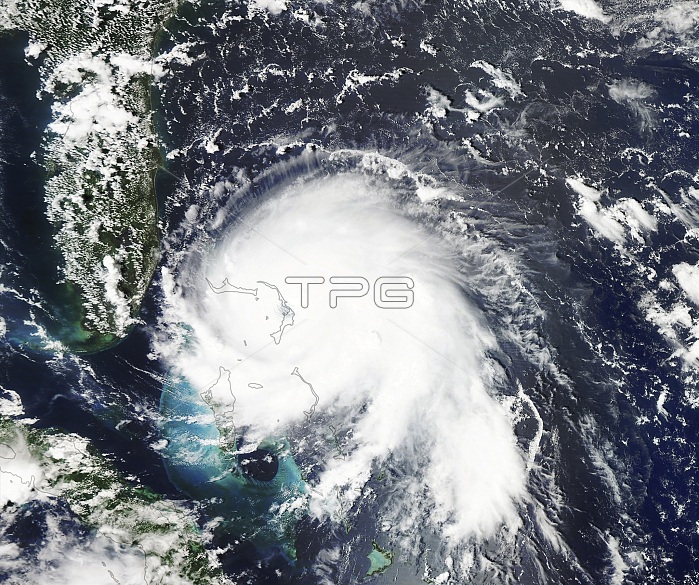
Hurricane Dorian over the Bahamas, satellite image. Hurricane Dorian reached category 5 strength on 1 September 2019, making landfall in the Bahamas where it caused extensive damage, deaths and flooding due to high winds, prolonged rainfall and storm surges, especially on islands and associated islands of Great Abaco and Grand Bahama (shown in outline). This image was obtained by the Moderate Resolution Imaging Spectroradiometer (MODIS) on NASA's Aqua satellite on 1 September 2019.
| px | px | dpi | = | cm | x | cm | = | MB |
Details
Creative#:
TOP25068319
Source:
達志影像
Authorization Type:
RM
Release Information:
須由TPG 完整授權
Model Release:
N/A
Property Release:
N/A
Right to Privacy:
No
Same folder images:
CYCLONICSTORMGEOGRAPHICALGEOSTATIONARYOPERATIONALENVIRONMENTALSATELLITEGOESGRANDBAHAMAGREATABACOMETEOROLOGICALNO-ONENOBODYWEATHEREOSDISLANCEGIBSMODERATERESOLUTIONIMAGINGSPECTRORADIOMETERHURRICANETROPICALCYCLONESTORMATLANTICOCEANBAHAMASCARIBBEANEARTHOBSERVATIONGEOGRAPHYMETEOROLOGYSATELLITEIMAGEFROMSPACEMODISAQUA21STCENTURY20191SEPTEMBER2019
12019201921STABACOAQUABAHAMABAHAMASCARIBBEANCENTURYCYCLONECYCLONICEARTHENVIRONMENTALEOSDISFROMGEOGRAPHICALGEOGRAPHYGEOSTATIONARYGIBSGOESGRANDGREATHURRICANEIMAGEIMAGINGLANCEMETEOROLOGICALMETEOROLOGYMODERATEMODISNO-ONENOBODYOBSERVATIONOCEANOPERATIONALRESOLUTIONSATELLITESATELLITESEPTEMBERSPACESPECTRORADIOMETERSTORMSTORMATLANTICTROPICALWEATHER
 Loading