
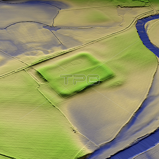
3D LiDAR model of Forden Gaer a Roman fort in Powys, Wales. The digital terrain model offers a view of the surrounding landscape without obstruction from foliage. The Roman settlement was established in the mid-1st century CE and was focused on a large earthwork enclosure. The fort was strategically built on the old Roman Road, which runs between Wroxeter and Caersws, and crosses the River Severn. Image contains UK public sector information licensed under the Open Government Licence v3.0.
| px | px | dpi | = | cm | x | cm | = | MB |
Details
Creative#:
TOP29741325
Source:
達志影像
Authorization Type:
RM
Release Information:
須由TPG 完整授權
Model Release:
N/A
Property Release:
N/A
Right to Privacy:
No
Same folder images:
3daltimeterancientarchaeologicalarchaeologyarcheologicalarcheologybritainbritishcaerflosdefencedefensedefensivedigitalterrainmodeldtmeuropeeuropeanfordengaerhistoricalhistorylandscapelaserlavrobrintalevobrintalidarmodelmodelingmodellingmomumentno-onenobodyoldpowysprehistoricprehistoryromanscansettlementterraintopographicaltopographyukunitedkingdomviewwaleswelshygaer
3daltimeterancientarchaeologicalarchaeologyarcheologicalarcheologybritainbritishcaerdefencedefensedefensivedigitaldtmeuropeeuropeanflosfordengaergaerhistoricalhistorykingdomlandscapelaserlavrobrintalevobrintalidarmodelmodelmodelingmodellingmomumentno-onenobodyoldpowysprehistoricprehistoryromanscansettlementterrainterraintopographicaltopographyukunitedviewwaleswelshy
 Loading