
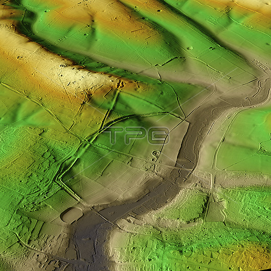
3D LiDAR model of Verulamium in St Albans, UK. The digital terrain model offers a view of the surrounding landscape without obstruction from foliage. This was one of the largest towns in Roman Britain. Its population is estimated to have been around 15,000 to 20,000 inhabitants at its peak. Now, the site is a park and agricultural land and a large portion remains unexcavated. Image contains UK public sector information licensed under the Open Government Licence v3.0.
| px | px | dpi | = | cm | x | cm | = | MB |
Details
Creative#:
TOP29741389
Source:
達志影像
Authorization Type:
RM
Release Information:
須由TPG 完整授權
Model Release:
N/A
Property Release:
N/A
Right to Privacy:
No
Same folder images:
3daltimeterancientarchaeologicalarchaeologyarcheologicalarcheologybritainbritishdefencedefensedefensivedigitalterrainmodeldtmeuropeeuropeanhertfordshirehistoricalhistorylandscapelaserlidarmodelmodelingmodellingmomumentno-onenobodyoldoverheadprehistoricprehistoryromanromanprovincescansettlementstalbansterraintopographicaltopographytownukunitedkingdomverlamioverulamium
3dalbansaltimeterancientarchaeologicalarchaeologyarcheologicalarcheologybritainbritishdefencedefensedefensivedigitaldtmeuropeeuropeanhertfordshirehistoricalhistorykingdomlandscapelaserlidarmodelmodelmodelingmodellingmomumentno-onenobodyoldoverheadprehistoricprehistoryprovinceromanromanscansettlementstterrainterraintopographicaltopographytownukunitedverlamioverulamium
 Loading