
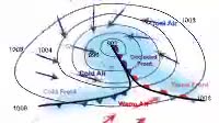
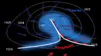
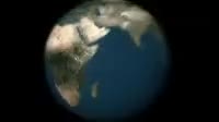
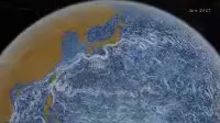
Animation of the development of a mid_latitude low pressure weather system, seen from above with north at top. Such systems form where warm air from the equator meets cool air from the poles, at a stationary front. Formation is typically driven by upper atmosphere air flows pulling air upwards. In the northern hemisphere, the Coriolis effect causes poleward_moving warm air red arrows to move eastwards, and polar air blue to move west. This leads to the front boundary developing a bend, and the start of a circular pattern of movement. Cold air is denser than warm air, and the cold front blue triangles undercuts warm air more quickly than warm front red semicircles can move into cold air, meaning the warm air is pushed upwards, lowering the air pressure beneath it. This aids the formation of a band of rain blue regions and high winds arrows. Black isobars show the air pressure at 4 millibar intervals, with a low pressure region at the centre of the developing system. Eventually the fast_moving cold front catches up the slower warm front, undercutting it and lifting it, causing more rain and the formation of an occluded front purple triangles and semicircles. With the warm air cut off from the system磗 centre the pressure rises as the air cools and sinks, leading to the dissipation of the occluded front and its associated rain, and the reforming of the stationary front boundary. These systems move eastwards over the surface of the Earth, and the passage of warm, cold and occluded fronts is responsible for the changeable weather in western Europe.
Details
WebID:
C00608631
Clip Type:
RM
Super High Res Size:
1920X1080
Duration:
000:25.000
Format:
QuickTime
Bit Rate:
25 fps
Available:
download
Comp:
200X112 (0.00 M)
Model Release:
NO
Property Release
No
 Loading