
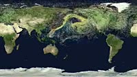
Fukushima global radiation release. Earth map animation cylindrical projection showing the release and spread of radioactivity coloured dots in the Earth磗 atmosphere following the Fukushima nuclear incident of March 2011. Prevailing eastward winds carried the radiation over the northern Pacific and all around the northern hemisphere. The level of radiation is exponentially colour_coded key at bottom, in becquerels from high radiation levels red, orange and yellow to low radiation levels blue, purple and pink. Each colour change is a multiple of ten. This radiation release took place in north_east Japan following damage to the Fukushima Daiichi Nuclear Power Station caused by the tsunami that resulted from the 2011 Tohuku East Japan earthquake of 11 March 2011. The simulation used here is the Hybrid Single_Particle Lagrangian Integrated Trajectory HYSPLIT model, developed by NOAA the US National Oceanic and Atmospheric Administration to follow the transport and dispersion of pollutants in the atmosphere. Calculated elements include wind transport, turbulent dispersion, scavenging and decay. This simulation shows a continuous release of tracer particles from 12_31 March at a rate of 100 per hour, representing the emitted caesium_137 half_life of 30 years. The simulation lasts until the end of April 2011. Particles with the highest radioactivity were released around 15 March, but levels decreased rapidly over time and distance due to removal from the atmosphere by rainfall and gravitational settling. Radiation decreases faster in low_pressure areas with higher rainfall compared to high pressure areas with fine weather. Animation published in April 2012. For a version without the key, see K003/3317.


Details
WebID:
C00617566
Clip Type:
RM
Super High Res Size:
1920X1080
Duration:
000:16.000
Format:
QuickTime
Bit Rate:
25 fps
Available:
download
Comp:
200X112 (0.00 M)
Model Release:
NO
Property Release
NO
 Loading