
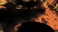
Global fire distribution in 2009. This map was created from data gathered by the MODIS instrument on NASA磗 Aqua and Terra satellites. It uses local temperature variations to pinpoint the location of fires. Fires are studied due to their emissions of gases and particulates, and so that their impact on the surrounding ecosystems can be analysed. Some of these fires are man_made, for instance by salsh_and_burn agriculture in forests, while others are natural wildfires.
Details
WebID:
C00605493
Clip Type:
RM
Super High Res Size:
1920X1080
Duration:
000:06.000
Format:
QuickTime
Bit Rate:
25 fps
Available:
download
Comp:
200X112 (0.00 M)
Model Release:
NO
Property Release
NO
 Loading