
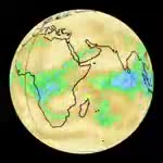
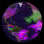
Animation showing the imaging swathes captured by the Aqua satellite over the course of one day. Aqua orbits the Earth at an altitude of 705 kilometres every 99 minutes, in a polar orbit passing within 10 degrees of each pole every orbit. The orbit is sun_synchronous, which means that the satellite passes over the same spot of the Earth at about the same local time everyday. Aqua crosses the equator from south to north at about 13:30 local time. The imaging swathe collected by the MODIS instrument is over 2300km wide. This means that MODIS is able to measure almost the entire Earth surface everyday. MODIS only collects data when it is on the sunlit side of the Earth because it measures reflected light from the Sun. The bright band that appears in the middle of some of the swathes is reflected sunlight off of the ocean. Images captured on 27th August 2005.


Details
WebID:
C00608466
Clip Type:
RM
Super High Res Size:
Duration:
000:58.000
Format:
QuickTime
Bit Rate:
25 fps
Available:
download
Comp:
150X150 (0.00 M)
Model Release:
NO
Property Release
No
 Loading