
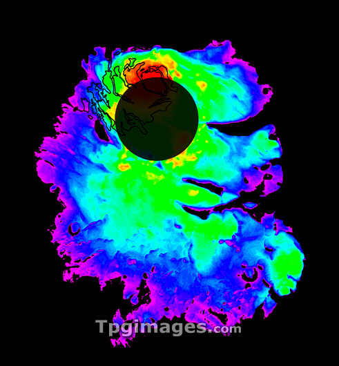
Mars' polar ice cap, altimetric radar image. Map showing the variation in thickness across the ice cap at Mars' south pole. The thickness of the cap is colour-coded from purple (0-0.5 kilometres, thinnest) through to red (3.5 kilometres, thickest). The total volume of ice contained in the cap is the equivalent to a layer of water 11 metres deep across the planet. The thickness of the cap was measured using the Mars Advanced Radar for Subsurface and Ionospheric Sounding (MARSIS) onboard the Mars Express orbiter. To generate the map, this data was combined with topographic data obtained by the Mars Orbiter Laser Altimeter onboard the Mars Global Surveyor orbiter. The dark circular area covers latitudes where data cannot be collected.
| px | px | dpi | = | cm | x | cm | = | MB |
Details
Creative#:
TOP03224293
Source:
達志影像
Authorization Type:
RM
Release Information:
須由TPG 完整授權
Model Release:
N/A
Property Release:
N/A
Right to Privacy:
No
Same folder images:
 Loading