
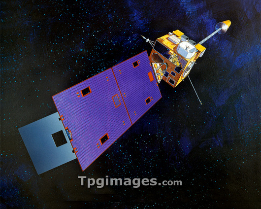
GOES-12 environmental satellite. Artwork showing the Geostationary Operational Environmental Satellite (GOES)-12. This satellite carries instruments to monitor weather conditions which aid the forecasting of hurricanes and severe storms. It also has a Solar X-ray Imager to detect storms on the surface of the Sun, which can influence the weather on Earth. The satellite has been in geostationary orbit 36,000 kilometres above the Equator since its launch on 22nd July 2001 from Cape Canaveral, Florida, USA.
| px | px | dpi | = | cm | x | cm | = | MB |
Details
Creative#:
TOP03225620
Source:
達志影像
Authorization Type:
RM
Release Information:
須由TPG 完整授權
Model Release:
N/A
Property Release:
N/A
Right to Privacy:
No
Same folder images:
GOES-12GOES-MSATELLITESPACEORBITINGTECHNOLOGYSPACEFLIGHTMETEOROLOGYGEOGRAPHYEARTHOBSERVATIONARTWORK21STCENTURYGEOGRAPHICALMETEOROLOGICALWEATHERTECHNOLOGICALILLUSTRATIONMETEOROLOGYMETEOROLOGICALSATELLITESATELLITESGEOSTATIONARYOPERATIONALENVIRONMENTALGODDARDSPACEFLIGHTCENTERWEATHERFORECASTINGMONITORINGFORECASTMONITORORBITUSAUNITEDSTATESAMERICANUSSOLARSTORMSTORMSHURRICANEHURRICANES
21STAMERICANARTWORKCENTERCENTURYEARTHENVIRONMENTALFLIGHTFLIGHTFORECASTFORECASTINGGEOGRAPHICALGEOGRAPHYGEOSTATIONARYGODDARDGOES-12GOES-MHURRICANEHURRICANESILLUSTRATIONMETEOROLOGICALMETEOROLOGICALMETEOROLOGYMETEOROLOGYMONITORMONITORINGOBSERVATIONOPERATIONALORBITORBITINGSATELLITESATELLITESATELLITESSOLARSPACESPACESPACESTATESSTORMSTORMSTECHNOLOGICALTECHNOLOGYUNITEDUSUSAWEATHERWEATHER
 Loading