
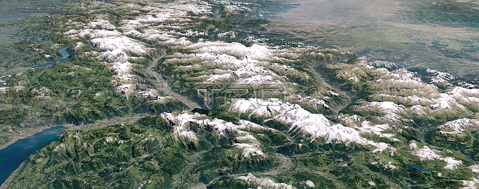
The Alps. Simulated 3D high-altitude panoramic view of the Alps, viewed from the west. Image based on Landsat satellite images and detailed digital terrain data. Prominent physical features include the Mont Blanc Massif and the Chamonix Valley (foreground centre), Lake Geneva (foreground left), the broad valley of the Rhone river (centre), with the Pennine Alps and the Aosta Valley to the south (right) and the Bernese Alps and Swiss lakes to the north (left). Individual peaks may be discerned, including Mt Blanc, the Matterhorn and the Eiger. In the distance lie Lake Maggiore, Milan and Italy's Po Basin (top right), and Lake Constance on the Swiss/German border (top left).
| px | px | dpi | = | cm | x | cm | = | MB |
Details
Creative#:
TOP10705199
Source:
達志影像
Authorization Type:
RM
Release Information:
須由TPG 完整授權
Model Release:
No
Property Release:
No
Right to Privacy:
No
Same folder images:
 Loading