
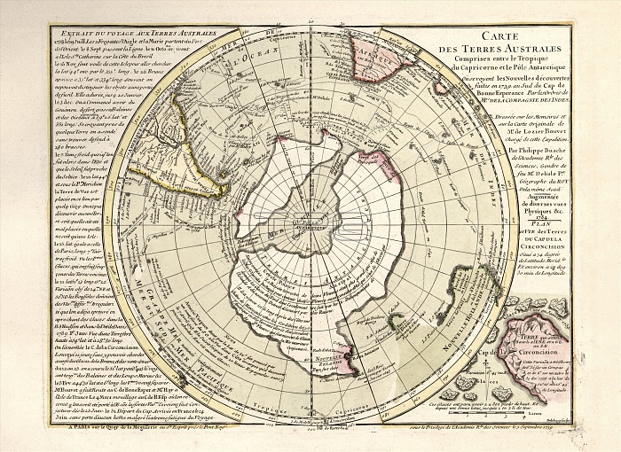
Map of Antarctica. 18th-century map showing the supposed form of the recently discovered southern continent of Antarctica. The map incorrectly shows Antarctica as two land masses separated by a sea over the South Pole. The labels, text and inscriptions are in French. This map is from 'Cartes et tables de la geographie physique ou naturelle' (1757) by French geographers and cartographers Philippe Buache (1700-1773) and Guillaume de l'Isle (1675-1726).
| px | px | dpi | = | cm | x | cm | = | MB |
Details
Creative#:
TOP16028991
Source:
達志影像
Authorization Type:
RM
Release Information:
須由TPG 完整授權
Model Release:
N/A
Property Release:
N/A
Right to Privacy:
No
Same folder images:
1700s175718thcenturyantarcticantarcticaartworkcartesettablesdelageographiephysiqueounaturellecartographycontinentfrenchfrenchlanguagegeographicalgeographyguillaumedel'isleguillaumedelislehistoricalhistoryillustrationlabellabeledlabelledlabelsmapno-onenobodyoceanographyphilippebuachephysicalgeograhytext
1700s175718thantarcticantarcticaartworkbuachecartescartographycenturycontinentdededelisleetfrenchfrenchgeograhygeographicalgeographiegeographyguillaumeguillaumehistoricalhistoryillustrationl'islelalabellabeledlabelledlabelslanguagemapnaturelleno-onenobodyoceanographyouphilippephysicalphysiquetablestext
 Loading