
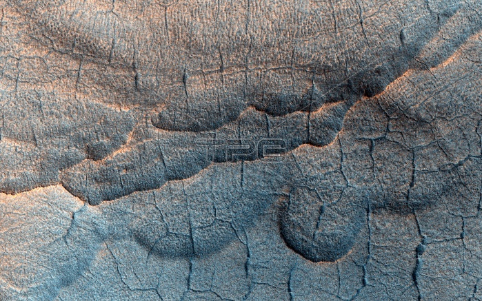
Thermokarst landscape on Mars, satellite image. This landscape includes features thought to have formed due to the influences of liquid water and ice. Examples are polygonal patterns of troughs and large scallop-shaped depressions. Fractures appear when ice-rich soil contracts each winter. Collectively, such landforms are referred to as 'thermokarst'. These observations were made by the High Resolution Imaging Science Experiment (HiRISE) camera on NASA's Mars Reconnaissance Orbiter (MRO) spacecraft. Image published in 2013.
| px | px | dpi | = | cm | x | cm | = | MB |
Details
Creative#:
TOP20028327
Source:
達志影像
Authorization Type:
RM
Release Information:
須由TPG 完整授權
Model Release:
N/A
Property Release:
N/A
Right to Privacy:
No
Same folder images:
NO-ONENOBODYMARTIANHIGHRESOLUTIONIMAGINGSCIENCEEXPERIMENTMARSRECONNAISSANCEORBITERGEOLOGICALFROMSPACEEROSIONFLOWFEATUREFEATURESWATERFLOWICETHERMOKARSTFRACTUREFRACTURESCRACKCRACKSARIDDESERTWORLDLANDSCAPEMARSPLANETSURFACESPACESOLARSYSTEMPLANETARYSCIENCEGEOLOGYAREOLOGYSATELLITEIMAGEHIRISEMROSATELLITE21STCENTURY2013
201321STAREOLOGYARIDCENTURYCRACKCRACKSDESERTEROSIONEXPERIMENTFEATUREFEATURESFLOWFLOWFRACTUREFRACTURESFROMGEOLOGICALGEOLOGYHIGHHIRISEICEIMAGEIMAGINGLANDSCAPEMARSMARSMARTIANMRONO-ONENOBODYORBITERPLANETPLANETARYRECONNAISSANCERESOLUTIONSATELLITESATELLITESCIENCESCIENCESOLARSPACESPACESURFACESYSTEMTHERMOKARSTWATERWORLD
 Loading