
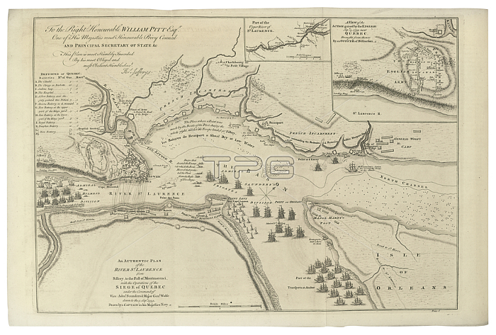
SWG368043 Map of St. Lawrence River from \'The Natural and Civil History of the French Dominions in North and South America\', published in 1760 (engraving) by Jefferys, Thomas (c.1719-71); 23x36.5 cm; Private Collection; (add.info.: Dedicated to William Pitt the Elder (1708-78); records the military operations of the siege of Quebec, under General James Wolfe and Admiral Charles Saunders; dated to 5 September 1759; as drawn by a Navy captain;); Courtesy of Swann Auction Galleries; English, out of copyright.
| px | px | dpi | = | cm | x | cm | = | MB |
Details
Creative#:
TOP26930898
Source:
達志影像
Authorization Type:
RM
Release Information:
須由TPG 完整授權
Model Release:
No
Property Release:
No
Right to Privacy:
No
Same folder images:
CanadacanadiancanadiansNorthAmericaAmerica(continent)westernhemispherenavynavalarmytroopsarmedforcescartographywarfarestrategyinscriptioncanadianstrategichistoricalcoloniesbattleoftheplainsofabrahammapvictorycolonialtacticstacticalcartographicbattleofquebecsevenyears\'warwarfarestrategyinscriptioncanadianstrategichistoricalcoloniesbattleoftheplainsofabrahamcanadanavalmapvictorycolonialtacticstacticalcartographicbattleofquebecsevenyears'war
(continent)AmericaAmericaCanadaNorthabrahamabrahamarmedarmybattlebattlebattlebattlecanadacanadiancanadiancanadiancanadianscartographiccartographiccartographycolonialcolonialcoloniescoloniesforceshemispherehistoricalhistoricalinscriptioninscriptionmapmapnavalnavalnavyofofofofofofplainsplainsquebecquebecsevensevenstrategicstrategicstrategystrategytacticaltacticaltacticstacticsthethetroopsvictoryvictorywarwarwarfarewarfarewesternyears'years\'
 Loading