
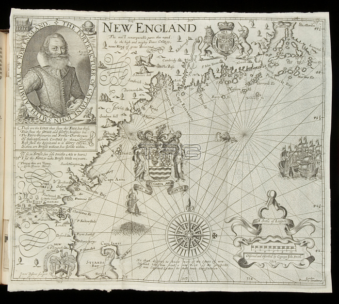
3964030 Map of New England, from \'Historia Mundi: or Mercator??? Atlas\', London, 1635 (engraving) by Mercator, Gerardus (1512-94); 18.3x28.6 cm; By kind permission of the Earl of Leicester and the Trustees of the Holkham Estate.
| px | px | dpi | = | cm | x | cm | = | MB |
Details
Creative#:
TOP27627304
Source:
達志影像
Authorization Type:
RM
Release Information:
須由TPG 完整授權
Model Release:
No
Property Release:
No
Right to Privacy:
No
Same folder images:
mapcartographybritishcolonialAmericaAmericanUnitedStatesUSANewEnglandUSmappingcolonycolonisationcoloniesdiscoverymapsNorthAmericaNewWorldrenaissancenorthernrenaissanceelizabethanjacobeanNorthAmericanamericashistoriamundiatlascartographybritishcolonialAmericaAmericanUnitedStatesUSANewEnglandUSmappingcolonycolonisationcoloniesdiscoverymapsNorthAmericaNewWorldrenaissancenorthernrenaissanceelizabethanjacobeanNorthAmericanamericashistoriamundiatlas
AmericaAmericaAmericaAmericaAmericanAmericanAmericanAmericanEnglandEnglandNewNewNewNewNorthNorthNorthNorthStatesStatesUSUSUSAUSAUnitedUnitedWorldWorldamericasamericasatlasatlasbritishbritishcartographycartographycolonialcolonialcoloniescoloniescolonisationcolonisationcolonycolonydiscoverydiscoveryelizabethanelizabethanhistoriahistoriajacobeanjacobeanmapmappingmappingmapsmapsmundimundinorthernnorthernrenaissancerenaissancerenaissancerenaissance
 Loading