
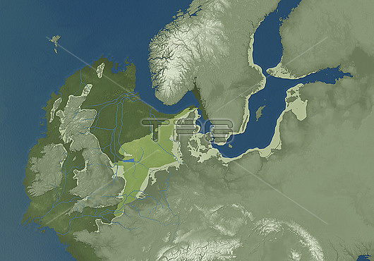
Prehistoric Doggerland region, illustration. Doggerland was an area of land that existed thousands of years ago when sea levels were lower. Part of the continental shelf of north-western Europe, it connected the British Isles to mainland Europe in what is now the North Sea. It was flooded by rising sea levels between 18,000 and 9000 years ago, shown here as colour-coded green areas. The key at top left gives the period when the land was above sea level: 16,000 BC (dark green), 8200 BC (light green), and 10000 BC (green). Rivers flowed across Doggerland, and it was an important land bridge that allowed early humans and animals to cross between what is now the British Isles and mainland Europe. Doggerland would have been inhabited during the Mesolithic (Middle Stone Age).
| px | px | dpi | = | cm | x | cm | = | MB |
Details
Creative#:
TOP27695494
Source:
達志影像
Authorization Type:
RM
Release Information:
須由TPG 完整授權
Model Release:
N/A
Property Release:
N/A
Right to Privacy:
No
Same folder images:
 Loading