
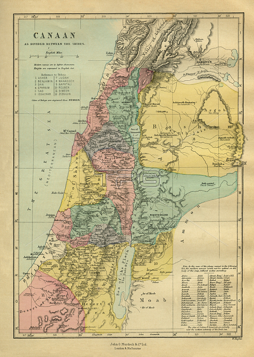
3788546 Map of Canaan by Morris, Philip Richard (1838-1902); (add.info.: 19th century map of Canaan (modern-day Israel, Palestinian territories, Lebanon, and the western parts of Jordan and Syria) as divided between different groups / tribes. Illustration by Philip R Morris (1836-1902). The Holy Bible: A commentary by Rev. Matthew Henry - illustrated by Philip M Morris (London: John G Murdoch, 1881)); Lebrecht History.
| px | px | dpi | = | cm | x | cm | = | MB |
Details
Creative#:
TOP28668429
Source:
達志影像
Authorization Type:
RM
Release Information:
須由TPG 完整授權
Model Release:
no
Property Release:
no
Right to Privacy:
No
Same folder images:
BibleChristianityreligioncartographyChristiancountryreligionsglobedrawingantiquitycountriesmaps19thcenturydrawingsmapillustrationsisraelearthcartographernineteenthreligionillustrationChristiancountryreligionsglobedrawingantiquitycountriesbiblemaps19thcenturydrawingsmapchristianityillustrationsisraelearthcartographernineteenthreligionillustration
19th19thBibleChristianChristianChristianityantiquityantiquitybiblecartographercartographercartographycenturycenturychristianitycountriescountriescountrycountrydrawingdrawingdrawingsdrawingsearthearthglobeglobeillustrationillustrationillustrationsillustrationsisraelisraelmapmapmapsmapsnineteenthnineteenthreligionreligionreligionreligionsreligions
 Loading