
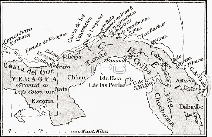
Map of Veragua showing coastline explored by Christopher Columbus on his fourth voyage; in 1502. From the book Life of Christopher Columbus by Clements R. Markham published 1892.
| px | px | dpi | = | cm | x | cm | = | MB |
Details
Creative#:
TOP29380335
Source:
達志影像
Authorization Type:
RM
Release Information:
須由TPG 完整授權
Model Release:
no
Property Release:
no
Right to Privacy:
No
Same folder images:
ColumbusChristopher(1451-1506)christophercolombusChristopher(1451-1506)ChristopherColombusChristopherColumbus(1451-1506)15thcentury15centuryXVcenturyXVthcenturyfifteenthcenturyc15th1515th15th15th15th15th15th15thcentury1515thXVXVthcentury515th15th15th15th15th15th15thcenturyLate15thCentury15th15XVXVthfifteenthcenturyexplorerexplorersItalyitalianitaliansitalianitalianitalianitalianitalianitalianitalianitalianitalianitalianitalianitalianitalianitalianitalianEuropeeuropeanEuropaecoastcoastlinecoastalCoastSceneshorelinecoastlineshoreseamaritimecartographycentralcoastlinediscoverygeographicalmapmakingcolonchartvoyageexplorationmapgeographyexplorerexploredamericafourth1502veraguascostaorodelVeragua
(1451-1506)(1451-1506)(1451-1506)15151515150215th15th15th15th15th15th15th15th15th15th15th15th15th15th15th15th15th15th5CenturyChristopherChristopherChristopherChristopherCoastColombusColumbusColumbusEuropaeEuropeItalyLateSceneVeraguaXVXVXVXVthXVthXVthamericac15thcartographycentralcenturycenturycenturycenturycenturycenturycenturycenturycenturychartchristophercoastcoastcoastalcoastlinecoastlinecolombuscoloncostadeldiscoveryeuropeanexplorationexploredexplorerexplorerexplorersfifteenthfifteenthfourthgeographicalgeographyitalianitalianitalianitalianitalianitalianitalianitalianitalianitalianitalianitalianitalianitalianitalianitalianitalianslinemapmapmakingmaritimeoroseashoreshorelineveraguasvoyage
 Loading