
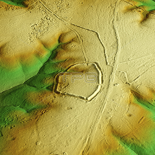
3D LiDAR scan of Ambresbury Banks in Essex, UK. The digital terrain model offers a view of the surrounding landscape without obstruction from foliage. This ancient hillfort dates back to the Iron Age, roughly between 700 BCE and 42 CE. It is believed to have been occupied and used for defensive purposes. Image contains UK public sector information licensed under the Open Government Licence v3.0.
| px | px | dpi | = | cm | x | cm | = | MB |
Details
Creative#:
TOP29741226
Source:
達志影像
Authorization Type:
RM
Release Information:
須由TPG 完整授權
Model Release:
N/A
Property Release:
N/A
Right to Privacy:
No
Same folder images:
3daltimeterambresburybanksancientarchaeologicalarchaeologyarcheologicalarcheologybritainbritishculturalculturedigitalterrainmodeldtmelevationenglandenglishessexeuropeeuropeanhillforthillfortshillforthillfortshistoricalhistoryironagelandscapelaserlidarlightdetectionandrangingmodelmodelingmodellingmonumentno-onenobodyprehistoricprehistoryscanscheduledterrainthreedimensionaltopographicaltopographyukunitedkingdom
3dagealtimeterambresburyancientandarchaeologicalarchaeologyarcheologicalarcheologybanksbritainbritishculturalculturedetectiondigitaldimensionaldtmelevationenglandenglishessexeuropeeuropeanfortfortshillhillhillforthillfortshistoricalhistoryironkingdomlandscapelaserlidarlightmodelmodelmodelingmodellingmonumentno-onenobodyprehistoricprehistoryrangingscanscheduledterrainterrainthreetopographicaltopographyukunited
 Loading