
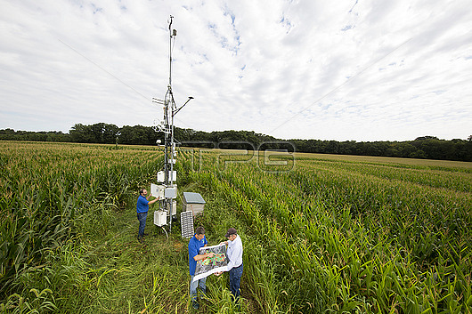
Scientists reviewing a map of LTAR (Long-Term Agroecosystem Research) fields and checking a sensor for data on carbon dioxide, water vapor, and energy exchanges between the Earths surface and the atmosphere. LTAR is a is a network of 18 research sites across the USA dedicated to improving agricultural efficiency whilst minimising harm to the environment. This is in an effort to solve the issue of the increasing food demand for a rapidly increasing population. Photographed at the ARS Henry A. Wallace Beltsville Research Center, Maryland, USA.
| px | px | dpi | = | cm | x | cm | = | MB |
Details
Creative#:
TOP29776524
Source:
達志影像
Authorization Type:
RM
Release Information:
須由TPG 完整授權
Model Release:
no
Property Release:
Right to Privacy:
No
Same folder images:
Restriction:
Editorial use only
agriculturalagricultureamericanantennacaucasiancollectingcropsdataenvironmentenvironmentalfarmfarmingfieldgatheringhenrya.wallacebeltsvilleresearchcenterlong-termagroecosystemresearchltarmalemapmarylandmastmenmonitormonitoringnorthamericanorthamericanobservingovercastplanningplantsresearchresearchingscientistssensorsensorsstrategisingstrategizingthreepeopleunitedstatesunitedstatesofamericaususawhite
a.agriculturalagricultureagroecosystemamericaamericaamericanamericanantennabeltsvillecaucasiancentercollectingcropsdataenvironmentenvironmentalfarmfarmingfieldgatheringhenrylong-termltarmalemapmarylandmastmenmonitormonitoringnorthnorthobservingofovercastpeopleplanningplantsresearchresearchresearchresearchingscientistssensorsensorsstatesstatesstrategisingstrategizingthreeunitedunitedususawallacewhite
 Loading